
Overview - Dover Project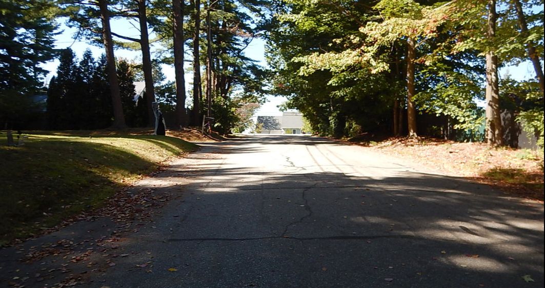
Dover, NH - Roberts Road - October 2, 2017
|
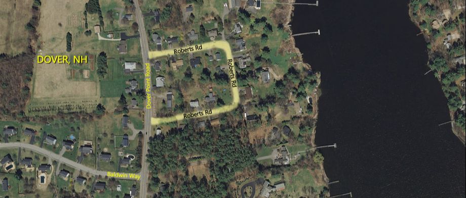
Roberts Road Project Area
Project Background
The City of Dover, New Hampshire selected Holden Engineering & Surveying, Inc. (HOLDEN) for the design of 1,400 linear feet of the reconstruction of Roberts Road, which is a residential neighborhood that’s adjacent to Dover Point Road to the west and the Piscataqua River on the border of New Hampshire and Maine to the east.
The City of Dover, New Hampshire selected Holden Engineering & Surveying, Inc. (HOLDEN) for the design of 1,400 linear feet of the reconstruction of Roberts Road, which is a residential neighborhood that’s adjacent to Dover Point Road to the west and the Piscataqua River on the border of New Hampshire and Maine to the east.
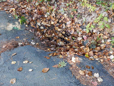
Roberts Road is suffering from lackluster drainage and deteriorating pavement conditions that have caused numerous issues for the residents. The stormwater is currently collected through storm drains and discharged through private property at three separate locations into the Piscataqua River. The City of Dover is primarily seeking out recommendations for improving and consolidating the drainage, but also for roadway improvements that include the following key features: creating a consistent road width, adding curbing to both sides of the roadway, and reclaiming and improving the roadway bed prior to repaving. In addition to the drainage and roadway improvements, the City of Dover also seeks assistance in obtaining drainage easements, permitting, and working with the City to recommend a construction contractor.

Project Requirements
Before the design recommendation for road and drainage modifications can be submitted, HOLDEN will complete survey work of the project area. In doing so, any easements will be located and addressed, observable landmarks will be noted, and both above ground and underground utilities will be located, some of which may need to be relocated for the construction of improvements.
Before the design recommendation for road and drainage modifications can be submitted, HOLDEN will complete survey work of the project area. In doing so, any easements will be located and addressed, observable landmarks will be noted, and both above ground and underground utilities will be located, some of which may need to be relocated for the construction of improvements.
Upon the completion of the base plan, HOLDEN will work with homeowners to acquire any approvals and easements as necessary for stormwater modifications. In conjunction with that, HOLDEN will also work with the New Hampshire Department of Environmental Services (NHDES) to determine which permits are required, if any, and will obtain them. Once the easements and permits are acquired, HOLDEN will coordinate the relocation of the existing utilities, if necessary, and will identify any trees that may be impacted or need to be removed in order to complete the road improvements and drainage modifications.
HOLDEN will develop a preliminary plan which will address all of the issues as noted by the City – roadway improvements, drainage consolidations, and impact on abutters, including potential right-of-way landscaping options – and present their findings to the community in an open forum setting, as well as smaller meetings with both city and state officials. The final bid plans will be stamped by a Professional Engineer and will include detailed cost estimates.
HOLDEN will develop a preliminary plan which will address all of the issues as noted by the City – roadway improvements, drainage consolidations, and impact on abutters, including potential right-of-way landscaping options – and present their findings to the community in an open forum setting, as well as smaller meetings with both city and state officials. The final bid plans will be stamped by a Professional Engineer and will include detailed cost estimates.
Roadway Existing Conditions
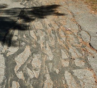
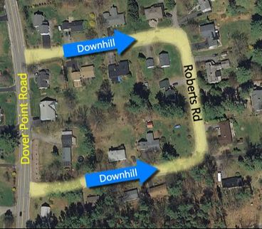
Roberts Road is approximately 1,400 linear feet long from the point it leaves Dover Point Road until it meets back up with Dover Point Road. The roadway descends on a gradual grade from its intersections with Dover Point Road, reaches a low point, and evens out on its east side (the side closest to the Piscataqua River). The pavement exhibits extensive cracking in a variety of forms.
Roadway Improvement Considerations
Using the base plan prepared from the field survey, HOLDEN will begin the design of the project improvements. HOLDEN will evaluate the existing right-of-way width to help determine how the new roadway typical section will fit within that width. The reconstructed roadway could potentially be built with two 11-foot travel lanes. HOLDEN will then establish a proposed profile so that sideline impacts are minimized on adjoining properties, and so that there are good driveway matches on both sides.
Drainage Existing Conditions
Using information obtained in our field survey in combination with data obtained from City records, HOLDEN will evaluate the existing drainage system in terms of condition (materials, age) and adequacy (size and extents to adequately service the contributing area). Ground surface elevations and visual observations will help determine where and if water is ponding in the street, at driveways, or along the perimeter of the roadway. Outfall locations will be examined for suitability. HOLDEN will assess where runoff from the street is finding its way onto private property and having a negative impact on those properties. The goal is to stop nuisance runoff from the roadway onto private property.
Using information obtained in our field survey in combination with data obtained from City records, HOLDEN will evaluate the existing drainage system in terms of condition (materials, age) and adequacy (size and extents to adequately service the contributing area). Ground surface elevations and visual observations will help determine where and if water is ponding in the street, at driveways, or along the perimeter of the roadway. Outfall locations will be examined for suitability. HOLDEN will assess where runoff from the street is finding its way onto private property and having a negative impact on those properties. The goal is to stop nuisance runoff from the roadway onto private property.
Drainage Improvement Considerations
HOLDEN field observations will also assess overland flow patterns. The goal is to determine the potential for surface flow and groundwater flow to seep into underlying roadbed materials, keeping them saturated. Saturated gravels provide little support to the overlying pavement, causing the pavement to crack and degrade prematurely under the weight of vehicle loads. Newly established road profiles will dictate where drainage structures are needed. Portions of the existing drainage system may be suitable and capable of being utilized in the design.
HOLDEN will perform design calculations to determine runoff. Basins will be placed where needed and pipe sizes determined to handle the predicted flows. Underdrains will be placed in locations where the select gravels have the potential to become saturated. Underdrain systems are a key component in helping to keep the new roadbed select gravels dry, and thereby maintain the integrity of the new road pavement. The underdrains will be connected to the new closed drainage system catch basins.
Storm drainage improvements identified above will be considered and have to be coordinated with the location of other underground utilities to avoid conflicts with various piping systems. This will require close coordination with existing utility owners/departments so that the design of needed modifications can occur and be approved (utility clearances) in a timely manner.
Required Permits
This project will require a wetlands permit for the outfall of the storm drain.